Area of Hanoi City: Understanding the Size, Districts, and Urban Landscape of Vietnam’s Capital
Area of Hanoi City: Understanding the Size, Districts, and Urban Landscape of Vietnam’s Capital
When travelers first arrive in Hanoi, they often imagine a compact historic capital filled with motorbikes, ancient temples, and lively street markets. Yet few realize just how vast the modern city has become. Beyond the narrow alleys of the Hanoi Old Quarter lies a sprawling metropolitan region with rural villages, satellite towns, lakes, industrial zones, and rapidly growing suburbs.
Understanding the area of Hanoi city is essential for travelers, researchers, and anyone interested in Vietnam’s urban development. How large is Hanoi? How are its districts organized? And how has the city expanded into one of Southeast Asia’s largest capitals?
In this in-depth guide, we’ll explore the geography, districts, growth, and urban planning of Hanoi—helping you see the city beyond its famous tourist streets.
Overview of Hanoi’s Geographic Area

The capital of Vietnam covers an impressive 3,359 square kilometers (about 1,297 square miles). This makes Hanoi one of the largest capital cities in Southeast Asia by area.
The city’s current boundaries were largely formed after a major administrative expansion in 2008, when surrounding provinces and districts were merged into Hanoi. This dramatically increased the city’s total area and population.
Key Geographic Facts About Hanoi
Total area: ~3,359 km²
Population: Over 8 million residents
Location: Northern Vietnam, along the Red River
Region: Part of the Red River Delta
The Red River plays a central role in Hanoi’s geography, shaping its fertile agricultural zones and influencing the development of the historic urban core.
Hanoi City Map and Urban Layout
At first glance, Hanoi’s layout can feel complex. Unlike many modern planned capitals, its structure evolved gradually over centuries—from imperial citadel to colonial center to megacity.
Major Urban Zones
Hanoi can broadly be divided into three zones:
Historic Core
Includes the Old Quarter and colonial districts
Cultural and tourism center
Urban Districts
High-density residential and commercial areas
Government buildings, offices, universities
Rural & Suburban Areas
Agricultural land
Traditional villages and craft communities
This layered structure reflects Hanoi’s long history, from the ancient capital of Thăng Long to the modern metropolis we see today.
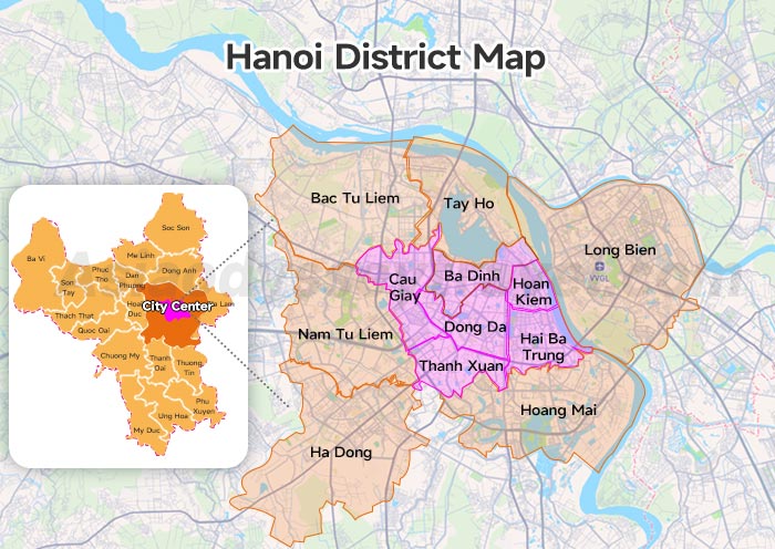
Administrative Districts of Hanoi
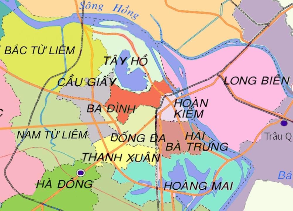
Today, Hanoi is divided into 30 administrative units, including urban districts, rural districts, and a township.
Urban Districts
These are the most developed parts of the city where most economic activity takes place.
Examples include:
Ba Đình District – Political center
Hoàn Kiếm District – Historic and tourism hub
Đống Đa District – Dense residential area
Cầu Giấy District – Technology and education hub
Tây Hồ District – Home to West Lake and many expatriates
These districts cover a relatively small part of the total city area but contain the majority of Hanoi’s economic activity.
Rural Districts
Hanoi also includes large rural districts that contribute significantly to its total area.
Examples include:
Ba Vì District
Sóc Sơn District
Thanh Trì District
Gia Lâm District
These areas contain farmland, mountains, national parks, and traditional villages.
For instance, Ba Vì National Park sits within Hanoi’s territory, offering forests, temples, and mountain landscapes far removed from the city center.
Hanoi Area Compared to Other Cities
To better understand Hanoi’s size, it helps to compare it with other major cities.
| City | Country | Area |
|---|---|---|
| Hanoi | Vietnam | ~3,359 km² |
| Bangkok | Thailand | ~1,569 km² |
| Singapore | Singapore | ~734 km² |
| Paris | France | ~105 km² |
Key takeaway: Hanoi’s administrative area is far larger than many global cities, although much of it includes rural land.
The 2008 Expansion That Transformed Hanoi
One of the most important moments in the city’s modern history was the 2008 administrative merger.
During this change, Hanoi absorbed:
The entire former province of Hà Tây Province
The district of Mê Linh District
Several communes from neighboring provinces
Results of the Expansion
The merger had dramatic impacts:
Tripled the city’s land area
Expanded population and economic potential
Allowed more space for future urban planning
Integrated rural economies with urban growth
Urban planners saw the expansion as necessary for Hanoi to develop into a modern regional megacity.
Urban Growth and Infrastructure Development
As Hanoi’s area expanded, so did its infrastructure.
Major projects have reshaped the city in recent years:
Urban rail lines
New ring roads
Satellite towns
International airport upgrades
The main airport serving the capital is Noi Bai International Airport, located in Sóc Sơn District north of the city center.
Transportation Networks
Hanoi’s growing size has required major transportation investments:
Ring Road 3 and 4 highways
New metro lines
Red River bridges
These developments aim to connect outer districts to the historic urban core more efficiently.
Natural Landscapes Within Hanoi’s Area
Despite its urban expansion, Hanoi still contains remarkable natural landscapes.
Major Lakes
Hanoi is often called the “city of lakes.”
Important lakes include:
West Lake
Hoàn Kiếm Lake
Trúc Bạch Lake
These lakes not only beautify the city but also play roles in flood control and local culture.
Mountains and Forests
In western Hanoi, mountainous areas such as Ba Vì provide:
National parks
Biodiversity reserves
Historic temples
This diversity makes Hanoi unique among world capitals.
Cultural and Historical Significance of Hanoi’s Geography
Hanoi’s geography is closely linked to its history.
The ancient citadel was strategically located near the Red River to support trade and agriculture. Over centuries, the city grew into the imperial capital of the Vietnamese dynasties.
Travelers exploring Hanoi’s cultural heritage may also enjoy learning about the country’s past in this related resource:
For additional travel insights and stories about the city, you can explore:
Expert Insight: Why Hanoi’s Size Matters
Urban planners frequently highlight Hanoi as an example of a rapidly evolving Asian capital.
According to regional urban development experts:
“Hanoi’s expanded administrative area provides long-term space for growth, infrastructure planning, and environmental protection.”
This strategic expansion allows the city to balance modernization with heritage preservation.
Key Takeaways About the Area of Hanoi City
Hanoi covers approximately 3,359 km², making it one of Southeast Asia’s largest capitals by area.
The city contains 30 administrative districts, including urban and rural areas.
A major 2008 expansion tripled the city’s size.
Natural landscapes like mountains, rivers, and lakes remain part of the metropolitan territory.
Ongoing infrastructure projects aim to connect outer districts with the historic center.
Conclusion: Hanoi’s Area Reflects Its Past and Future
Hanoi is far more than its bustling Old Quarter. Its vast territory includes historic neighborhoods, growing suburbs, farmland, mountains, and rivers—all part of a complex urban landscape.
The area of Hanoi city tells the story of a capital balancing centuries of history with the demands of modern growth. From ancient imperial roots to emerging megacity, Hanoi continues to expand while preserving the cultural identity that makes it one of Asia’s most fascinating destinations.
If you’re planning a trip, studying Vietnam’s geography, or exploring urban development in Southeast Asia, understanding Hanoi’s size and structure offers valuable insight into the heart of the country.
Ready to explore more about Vietnam’s culture, history, and cities?
Dive deeper into Vietnam travel guides and discover what makes this country truly unforgettable.


Nhận xét
Đăng nhận xét